קובץ:1806 Cary Map of Tartary or Central Asia - Geographicus - Tartary-cary-1806.jpg

תוכן הדף אינו נתמך בשפות אחרות.
מתוך ויקיפדיה, האנציקלופדיה החופשית

לקובץ המקורי(5,000 × 4,569 פיקסלים, גודל הקובץ: 8.57 מ"ב, סוג MIME‏: image/jpeg)

ויקישיתוף זהו קובץ שמקורו במיזם ויקישיתוף. תיאורו בדף תיאור הקובץ המקורי (בעברית) מוצג למטה.
ג'ון קארי: A New Map of Mongolian & Independent Tartary , From the Latest Authorities.   (Wikidata search (Cirrus search) Wikidata query (SPARQL)  Create new Wikidata item based on this file)
אומן
ג'ון קארי  (–1835)  wikidata:Q3446124 s:en:Author:John Cary
 
שמות חלופיים
J. Cary
תיאור קרטוגרף, חרט, mapseller, printseller וגרפיקאי
תאריך לידה/פטירה ‏23 בפברואר 1755‏ / 1754 לערוך בוויקינתונים ‏16 באוגוסט 1835‏ לערוך בוויקינתונים
מיקום לידה/פטירה Corsley מורטלייק
פעל בתקופה 1788 / 1793 / 1797 לערוך בוויקינתונים
פעל ב
קובץ זהויות
artist QS:P170,Q3446124
כותרת
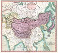
A New Map of Mongolian & Independent Tartary , From the Latest Authorities.
תיאור
English: An exceptionally beautiful example of John Cary’s important 1806 map of Mongolian and Independent Tartary. Covers Central Asia from the Caspian Sea to Japan, extends as far north as the Obskaia Sea and as far south as India, Burma and the Philippines. Includes the modern day nations of Uzbekistan, Kazakhstan, Turkmenistan, Kirgizstan, Tajikistan and Mongolia. One of Cary’s most interesting maps. Central Asia, despite hundreds of years of passing trade on the Silk Routes, was still, at the turn of the century a largely unknown land. Cary attempts to show some of the Silk Route passages, especially to the north of the Gobi, but ultimately admits, “The Geography of these parts is extremely obscure.” All in all, one of the most interesting and few maps of Central Asia to appear in first years of the 19th century. Prepared in 1806 by John Cary for issue in his magnificent 1808 New Universal Atlas. (NOTE: The reproduction of the colors in this map appear to be incorrect, as Japan and Tibet were never part of Chinese Tartary yet appear to be the same color as it.)
תאריך יצירה 1806 (dated)
ממדים גובה: 18.5 in (46.9 ס"מ); רוחב: 20 in (50.8 ס"מ)
dimensions QS:P2048,18.5U218593
dimensions QS:P2049,20U218593
מספר גישה
Geographicus link: Tartary-cary-1806
מקור/צלם

Cary, John, Cary's New Universal Atlas, containing distinct maps of all the principal states and kingdoms throughout the World. From the latest and best authorities extant. London: Printed for J. Cary, Engraver and Map-seller, No. 181, near Norfolk Street, Strand, 1808.

אישורים והיתרים
(שימוש חוזר בקובץ זה)
עבודת אמנות דו-מימדית זו המוצגת בתמונה שוחררה לרשות הציבור בכל העולם בעקבות תאריך מותו של היוצר, או תאריך פרסום היצירה. לפיכך, תצלום היצירה גם הוא ברשות הציבור.
Public domain
יצירה זו נמצאת בנחלת הכלל במדינת המקור ובמדינות אחרות בהם תקופת זכויות היוצרים היא משך חיי היוצר ו-100 שנה (או פחות) מפטירתו.

You must also include a United States public domain tag to indicate why this work is in the public domain in the United States.
הודעה זו תקפה לגבי התצלומים שנוצרו בארצות הברית, בגרמניה ובמדינות רבות נוספות.
גרסאות אחרות
Annotations
InfoField
This image is annotated: View the annotations at Commons

כיתובים

נא להוסיף משפט שמסביר מה הקובץ מייצג

פריטים שמוצגים בקובץ הזה

מוצג

image/jpeg

checksum אנגלית

3d7f1be3ae7a9539d26d91394bee37e7dc951779

הוגדר לפי: SHA-1 אנגלית

8,990,511 בית

4,569 פיקסל

5,000 פיקסל

היסטוריית הקובץ

ניתן ללחוץ על תאריך/שעה כדי לראות את הקובץ כפי שנראה באותו זמן.

תאריך/שעהתמונה ממוזערתממדיםמשתמשהערה
נוכחית11:56, 19 באוגוסט 2019תמונה ממוזערת לגרסה מ־11:56, 19 באוגוסט 2019‪4,569 × 5,000‬ (8.57 מ"ב)SoerfmBrightness, color
13:56, 22 במרץ 2011תמונה ממוזערת לגרסה מ־13:56, 22 במרץ 2011‪4,569 × 5,000‬ (7.81 מ"ב)BotMultichillT{{subst:User:Multichill/Geographicus |link=http://www.geographicus.com/P/AntiqueMap/Tartary-cary-1806 |product_name=1806 Cary Map of Tartary or Central Asia |map_title=A New Map of Chinese & Independent Tartary , From the Latest Authorities. |description=

הדף הבא משתמש בקובץ הזה:

שימוש גלובלי בקובץ

אתרי הוויקי השונים הבאים משתמשים בקובץ זה:

מטא־נתונים